Contents:
Why stay in Karakol
Karakol is the main urban base for the eastern Issyk-Kul basin and the Terskey Ala-Too range. You can break a long journey here, rent equipment, find a driver or guide, and leave spare luggage before heading into the mountains. The city itself is roughly 13 kilometres from the lakeshore, so do not expect a beach at the end of the main street.
The centre retains a rectangular street grid, low-rise buildings and old wooden houses. You do not need a car for the main sights: the Dungan Mosque, Holy Trinity Cathedral, regional museum, central market and main square fit into one walk. Karakol deserves a day of its own rather than serving only as a car park before a trek.
What to see in Karakol
Dungan Mosque. The wooden mosque was built for Karakol's Dungan community between 1907 and 1910. Its painted eaves, carved details and tiered roof recall Chinese architecture, but this remains an active place of worship. Visit outside prayer times, dress modestly and ask a member of staff before taking photographs.
Holy Trinity Cathedral. The present wooden church was built from 1893 to 1895 after an earthquake damaged its predecessor. Carved window frames, the tall timber walls and green domes are easy to appreciate from outside. Inside, keep your voice down, do not interrupt a service and follow the parish rules on clothing and photography.
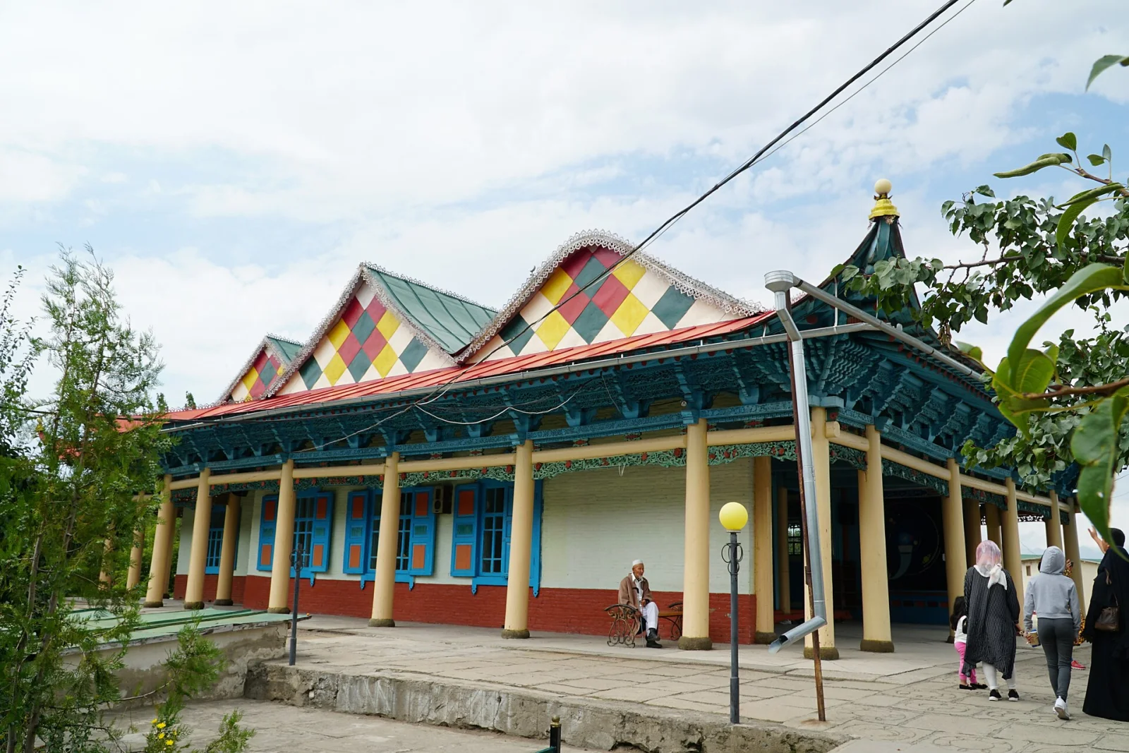 1/2. Dungan Mosque Photo: Adam Harangozó, Wikimedia Commons, CC BY-SA 4.0; edited for this site.
 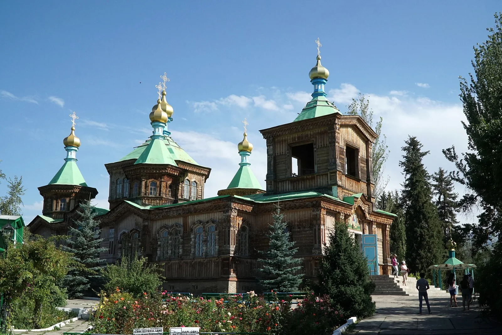 2/2. Holy Trinity Cathedral Photo: Adam Harangozó, Wikimedia Commons, CC BY-SA 4.0; edited for this site.
 History museum. The collection introduces the history of Karakol and the cultures of the surrounding region. One section displays photographs by the Swiss traveller Ella Maillart. Check opening hours and admission after the 2026 renovation before setting out.
Two museums, two routes. The Karakol History Museum is in the walkable centre and gives useful context before exploring the town. The Przhevalsky Museum is in Pristan-Przhevalsk beside Issyk-Kul, so it needs a separate short trip.
Central market. The market is worth seeing as part of everyday Karakol, not as a compulsory dose of local colour. Stalls sell produce, spices, dried fruit and prepared food. Ask before taking a close photograph of a vendor or customer, and keep your phone and wallet where you can feel them in the crowd.
Ashlyam-fu. Karakol's signature dish combines wheat noodles, strips of starch jelly, a vegetable sauce, vinegar and spicy laza. If you prefer mild food, ask for the laza on the side. Our guide to ashlyam-fu explains the ingredients and includes a home recipe.
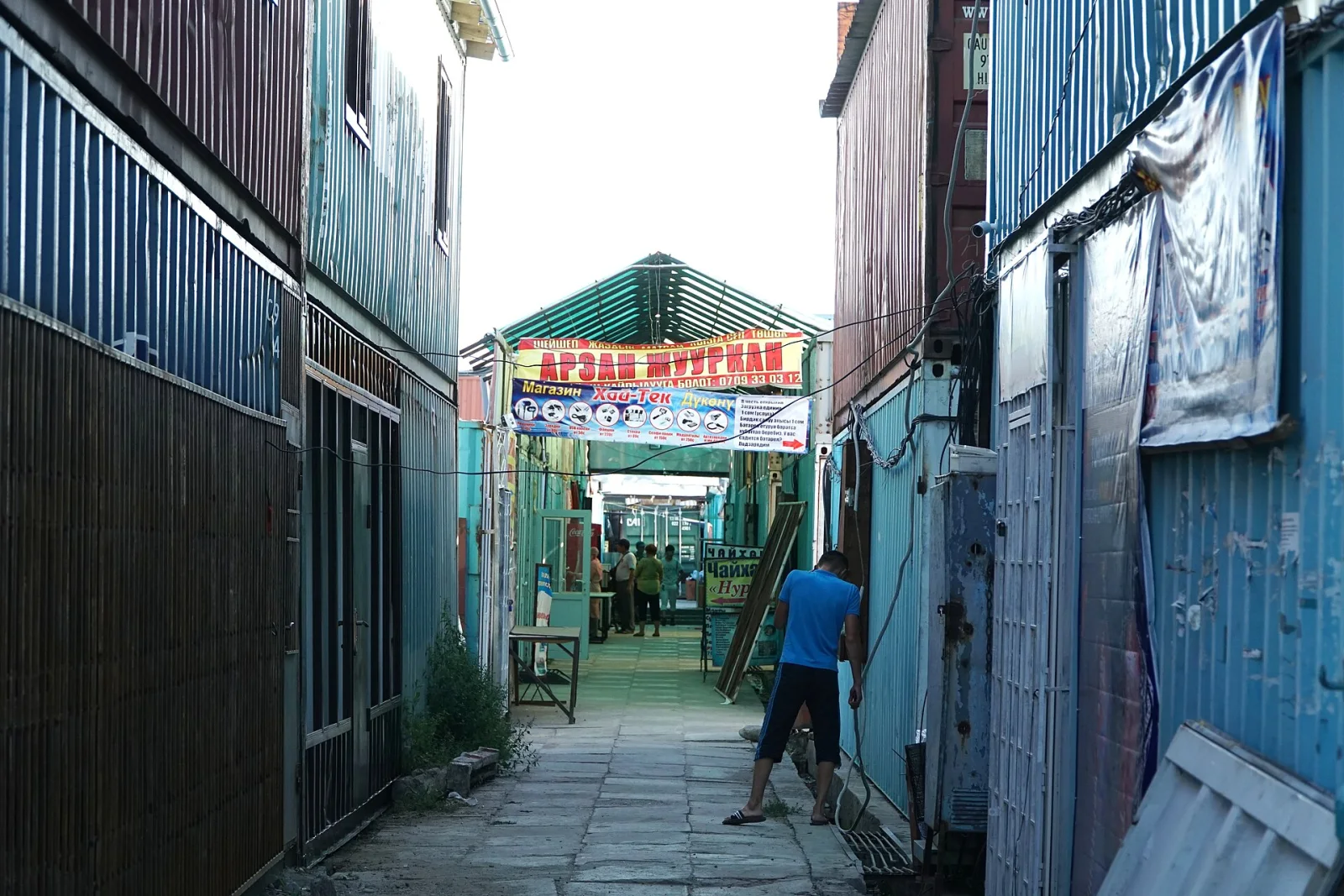 1/2. Central market Photo: Adam Harangozó, Wikimedia Commons, CC BY-SA 4.0; edited for this site.
 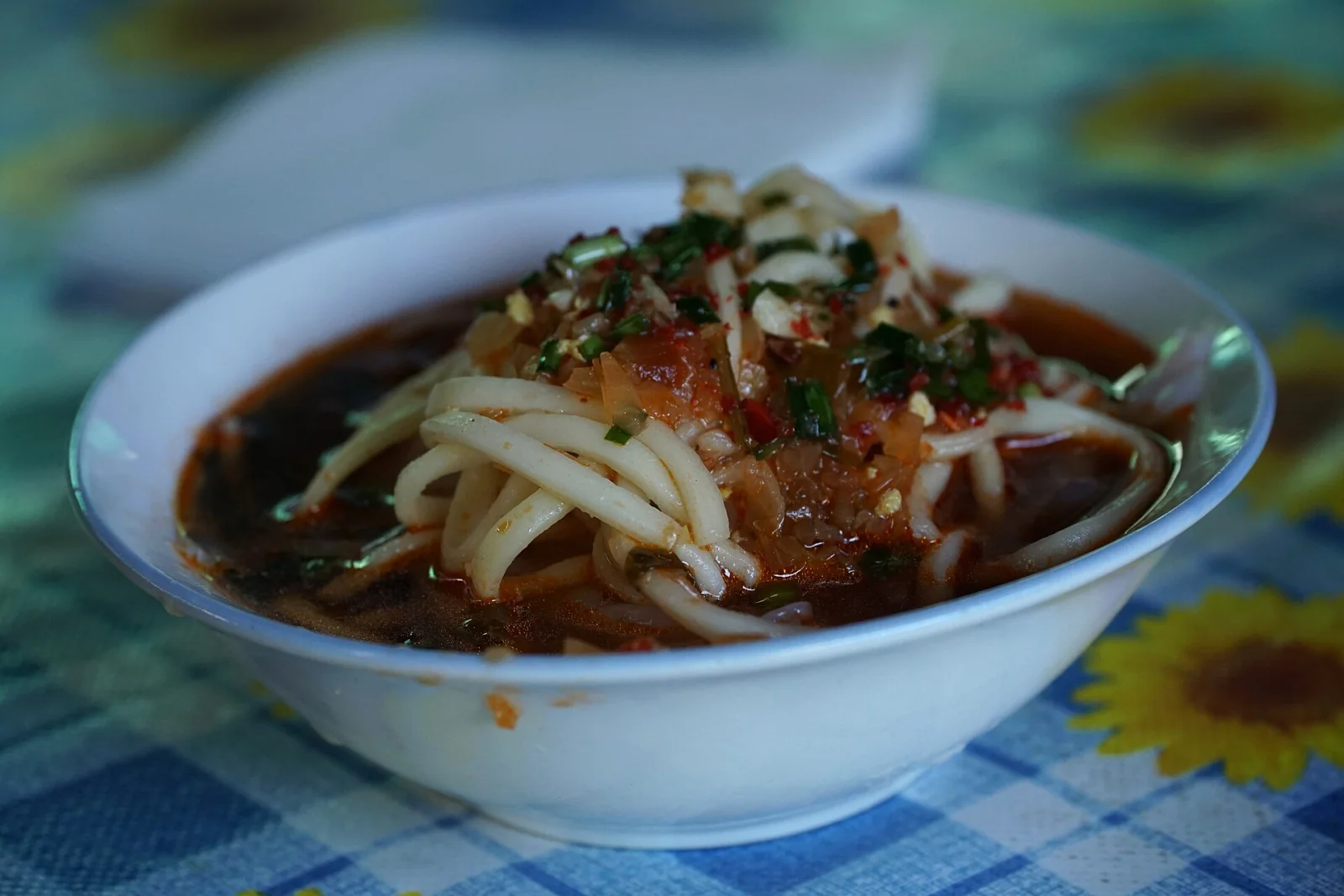 2/2. Karakol ashlyam-fu Photo: Adam Harangozó, Wikimedia Commons, CC BY-SA 4.0; edited for this site.
 Main square and city parks. The square by Issyk-Kul State University offers a quiet pause between sights. Tree-lined streets and parks show a different side of Karakol: little in the way of a set-piece attraction, but plenty of the everyday rhythm of a regional capital.
Half-day and one-day routes
Half a day. Start at the Dungan Mosque, walk through the market and stop for ashlyam-fu. Continue to Holy Trinity Cathedral and the main square. This route leaves room for a locked door, prayer time or a spell of rain, and avoids journeys across the whole city.
One day. Add the regional museum and one park. If the museum is closed, do not replace it with a distant gorge. Slow down and look at the wooden houses and carved window frames on the older streets instead. In the evening, prepare water, food, clothing and an offline map for the next day's outing.
Two days or more. Give the first day to Karakol, then choose one clear objective for each additional day. Hot springs, a high-altitude lake and red-rock formations lie in different directions and need different transport. A three-gorge day looks attractive only until the first delay on the road.
Getting to Karakol and around the city
Minibuses, coaches and shared taxis travel between Bishkek and Karakol. The journey usually takes around 6-7 hours, although roadworks, weather and stops can alter that estimate. Check the departure point, ticket and luggage arrangements in the current Destination Karakol transport guide. Older reviews may still direct you to a former bus station.
Drivers can approach Karakol along either the north or south shore of Issyk-Kul. Choose between them by considering the entire route, not just the mileage. Stops, roadworks and night driving matter more than a few minutes saved on paper. After a long transfer, do not plan to start a high-altitude trail on the same day.
Walking is the easiest way to cover the centre. Use a local minibus or taxi for the bus station, outer neighbourhoods, the Przhevalsky Museum and the start of roads out of town. Show the exact point on a map in advance. The name of a guesthouse or gorge may not mean the same final stop to both passenger and driver.
When to visit Karakol
June to September is the main season for using Karakol as a summer hiking base. Snow may remain on high passes in June, and trail access depends on actual conditions rather than the calendar. Before a multi-day trek, check bridges, river crossings, the forecast and whether a border-zone permit is required.
December to March is the core ski season. Snow, wind and maintenance determine which lifts, pistes and roads are open. Our page on the Karakol Ski Base explains the current trip format.
Spring and autumn suit city walks, local food and trips through the lower valleys. A high-mountain route can require winter equipment or be inaccessible at these times. Karakol stands at roughly 1,770 metres, so a warm layer is useful after sunset even on a bright day.
Trips from Karakol
Altyn Arashan. The valley and its hot springs need a full day or an overnight stay. The final road section is suitable for properly equipped four-wheel-drive vehicles, and the walk uphill is not a quick afternoon stroll.
Lake Ala-Kul. The high-altitude lake belongs to a demanding multi-day route over a mountain pass. No road reaches the shore. You need acclimatisation, warm and waterproof equipment, navigation and a plan for deteriorating weather.
Jeti-Oguz. The red cliffs, resort area and Kok-Jaiyk valley make a half-day or full-day trip. This is less demanding than a high-altitude crossing and works well for a first free day.
Przhevalsky Museum. The memorial complex is in Pristan-Przhevalsk, closer to the shore of Issyk-Kul. Treat it as a separate short trip rather than part of a walking route through central Karakol.
Where to stay in Karakol
In the centre. Accommodation near the main square, market or cathedral is convenient for a first short stay. You can walk to food and the city sights, using a taxi only for the bus station or a trip out of town.
In the south of the city. This location shortens the drive to the ski base and Karakol Gorge but puts you farther from the market and mosque. Check the actual walking route rather than relying on the word "centre" in a listing.
Before booking: ask whether you can leave luggage during a trek, dry wet clothing, get an early breakfast and arrange a vehicle to the trailhead. For a mountain trip, those four answers are more useful than the view from the window.
How the city became Karakol
Karakol was founded on 1 July 1869 as a military and administrative centre on the caravan route between the Chuy Valley and Kashgar. Its rectangular street grid appeared with the first squares and public buildings. A historical note from the city administration records the main dates and the plan of the old town.
In 1889 the city was renamed Przhevalsk in memory of Nikolai Przhevalsky, who died here before another expedition. The name Karakol returned in 1922, while Przhevalsk was restored in 1939. On 6 March 1992 the official name became Karakol again, and on 3 July it became the administrative centre of Issyk-Kul Region.
Before the Urkun of 1916, Yusup Abdrakhmanov, later the first head of government of the Kyrgyz ASSR, studied at the town’s higher primary school. His biography connects Karakol with the making of Kyrgyz autonomy and the generation of political leaders destroyed in 1938.
The city's story is more than a sequence of names. The Dungan Mosque, Orthodox cathedral, market, ashlyam-fu and wooden houses show how migration, trade, religion and daily life came together in one place. After a day in Karakol, the road into the mountains has more context.
Share on social media
If you found this guide useful, share it on social media. It takes a moment and helps more travellers discover the project. Thank you!
Anything to add?
Share your experience, leave a comment or suggest an improvement.