Contents:
Why stop in Tash-Kumyr
Tash-Kumyr occupies a narrow stretch of the Naryn valley on the road between the southern Fergana Valley and Toktogul. It is neither a resort nor a town built around a long museum checklist. Its appeal comes from an everyday industrial landscape where mining neighbourhoods, steep slopes, green river water and power infrastructure meet.
Allow 3-4 hours for the town. That gives you time to walk the central streets, find a safe river view and eat before moving on. A full day is useful when breaking the long journey from Osh to Toktogul, or before an early start towards Sary-Chelek.
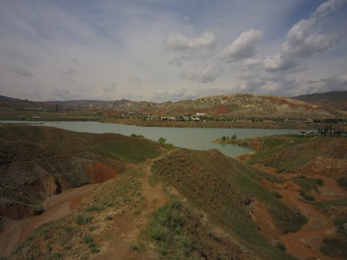 1/2. Shamaldy-Sai Reservoir in the Naryn valley Photo: Peter in s, Wikimedia Commons, CC BY-SA 3.0; edited for this site.
  2/2. An everyday street in Kyzyl-Jar Photo: Abdyrashit Satylganov, Wikimedia Commons, CC BY-SA 4.0; edited for this site.
 Set the right expectation. Tash-Kumyr works through its townscape and history, not one must-see attraction. Treat it as a purposeful stop on a longer route.
How coal gave the town its name
The Kyrgyz name Tash-Kömür literally means “stone coal”. Tash-Kumyr is the established Russian spelling. If you are searching for transport, an address or an official document, try both forms: they refer to the same town, but map and timetable searches may treat them differently.
A government programme on Kyrgyzstan's smaller towns dates Tash-Kumyr's formation to 1942 and connects it directly with coal mining. Archive records mention a mine administration in 1939. The pits and workers' settlements shaped the early street plan, employment and the character of the town.
Mining history does not make the pits safe visitor attractions. Keep out of mine workings, spoil heaps, railway tracks and company property unless you have explicit official permission. An open gate or old road may still lead into an active or unstable area.
The Naryn and hydropower
The Naryn determines the shape of Tash-Kumyr, with neighbourhoods squeezed into the strip between water and steep slopes. This section of the river forms part of a hydropower cascade. Tash-Kumyr Hydroelectric Power Station has a design capacity of 450 MW and a 75 m dam. The figures explain the scale, but the station remains a working industrial site.
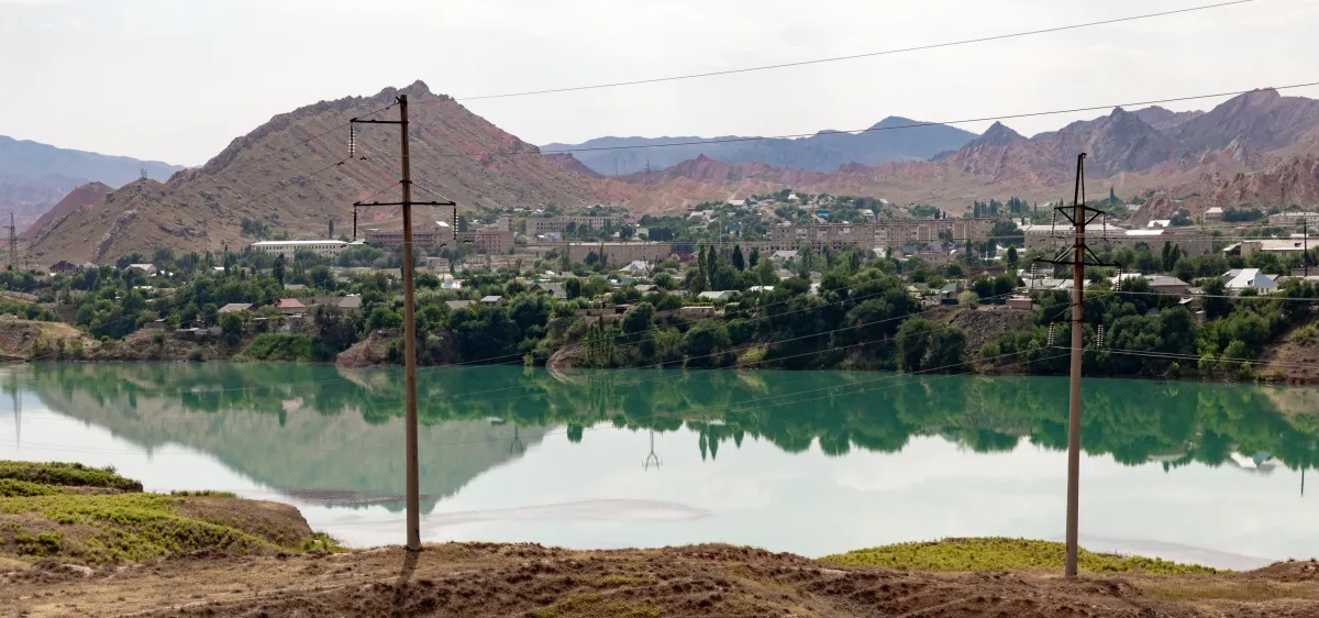 The town, the Naryn and its energy infrastructure. Photo: Ninara, Wikimedia Commons, CC BY 2.0; edited for this site.
View the river, dams and transmission lines only from public roads and authorised areas. Do not park at barriers, fly a drone near power installations or ignore security instructions. Water levels and currents below a dam can change quickly.
Older descriptions often treat Shamaldy-Sai downstream as part of Tash-Kumyr. An administrative reform made it a separate town in 2024, so do not use Tash-Kumyr as its district when searching for an address, accommodation or transport.
What to see in a few hours
The central streets. Begin near the market, shops and local transport. It is the easiest place to buy water and food, find a taxi and confirm the next departure point. Save a map pin immediately: shared taxis and minibuses may not leave from the spot where you arrived.
A view over town. Tash-Kumyr makes most sense from above, where you can see how the houses occupy a narrow ribbon between the river and the slopes. Use a public road or an explicitly authorised viewpoint. Loose scree and service tracks are not sensible shortcuts to a photograph.
The Naryn riverfront. Look for a safe view from a road or residential area rather than descending a steep, unstable bank. The water does not remain calm everywhere or at all times. Swimming near hydraulic structures should not be part of an improvised roadside stop.
A half-day or full-day plan
Half a day. Leave your luggage, confirm where your onward ride departs and walk the central streets. Find an authorised view of the Naryn and town panorama, have lunch, then return with time to spare. You do not need a car if your accommodation or transport stop is central.
One day. Add an unhurried walk through residential streets and a drive along the main road to a safe view across the valley. Do not turn spare time into an independent search for mines and dams. If industrial history is your main interest, arrange a legal route with a knowledgeable local guide beforehand.
Tash-Kumyr fits a broader itinerary better than a trip built around ticking off the name. Kara-Kul and Toktogul lie to the north, the road returns south towards Manas and Osh, while the western route leads through Kerben towards Sary-Chelek.
Getting there and travelling onwards
The official bus-station timetable lists direct services between Osh and Tash-Kumyr. Departure times, fares, operators and boarding points can change, so reconfirm the service on the day. Shared transport may wait until full, and the actual stop in town may differ from the formal bus station.
Northbound traffic follows the main road through Kara-Kul to Toktogul Reservoir. The western turn leads towards Kerben and Arkyt, the gateway for Sary-Chelek. Leave daylight and time for transfers, and do not rely on the last connection without confirmation.
Drivers should refuel before long mountain sections and avoid parking in narrow places beside the river. Our Kyrgyzstan transport guide explains the main options, payment habits and ways to find a ride.
When to visit and where to stay
Spring and autumn make daytime walks and onward drives easier, without the strongest heat. Take care on unpaved turn-offs and loose slopes after rain. In summer, walk in the morning or evening, carry water and never leave people or animals in a parked car.
In winter, daylight is shorter and shaded road sections may hold ice or fallen stones. Check the forecast and pass conditions before continuing through the mountains. Before booking a room, confirm heating, hot water, parking and late check-in.
Choose accommodation near the real departure point rather than relying only on its distance from the centre on a map. Tash-Kumyr is most useful as a pause between long drives: sleep, restock water and continue in the morning when the valley and mountain road are clearly visible.
Share on social media
If you found this guide useful, share it on social media. It takes a moment and helps more travellers discover the project. Thank you!
Anything to add?
Share your experience, leave a comment or suggest an improvement.